Beautiful Nature
Beatiful Nature.All about nature.amazing photos and summary info. wonderful natural places like: mountains,volcanos,deserts,caves,canyons,lakes,fjords,rivers,waterfalls,valleys,national park,geysir,cliffs,rock formations...
Showing posts with label Desert. Show all posts

Sahara


The Sahara is the world's largest hot desert. At over 9,400,000 square kilometres (3,630,000 sq mi), it covers most of Northern Africa, making it almost as large as Europe or the United States. The only larger desert in the world is Antarctica. The Sahara Desert stretches from the Red Sea, including parts of the Mediterranean coasts, to the outskirts of the Atlantic Ocean. To the south, it is delimited by the Sahel: a belt of semi-arid tropical savanna that comprises the northern region of central and western Sub-Saharan Africa. Some of the sand dunes can reach 180 metres (590 ft) in height.

Overview

The Sahara's boundaries are the Atlantic Ocean on the west, the Atlas Mountains and the Mediterranean Sea on the north, the Red Sea and Egypt on the east, and the Sudan and the valley of the Niger River on the south. The Sahara is divided into western Sahara, the central Ahaggar Mountains, the Tibesti Mountains, the Air Mountains (a region of desert mountains and high plateaus), Ténéré desert and the Libyan desert (the most arid region). The highest peak in the Sahara is Emi Koussi (3,415 m/11,204 ft) in the Tibesti Mountains in northern Chad.

The Sahara divides the continent of Africa into North and Sub-Saharan Africa. The southern border of the Sahara is marked by a band of semiarid savanna called the Sahel; south of the Sahel lies the lusher Sudan and the Congo River Basin. Most of the Sahara consists of rocky hamada; ergs (large sand dunes) form only a minor part.

People lived on the edge of the desert thousands of years ago since the last ice age. The Sahara was then a much wetter place than it is today. Over 30,000 petroglyphs of river animals such as crocodiles survive, with half found in the Tassili n'Ajjer in southeast Algeria. Fossils of dinosaurs, including Afrovenator, Jobaria and Ouranosaurus, have also been found here. The modern Sahara, though, is not lush in vegetation, except in the Nile Valley, at a few oases, and in the northern highlands, where Mediterranean plants such as the olive tree are found to grow. The region has been this way since about 5000 years ago. Some 2.5 million people currently live in the Sahara, most of these in Egypt, Mauritania, Morocco and Algeria. Dominant ethnicities in the Sahara are various Berber groups including Tuareg tribes, various Arabised Berber groups such as the Hassaniya-speaking Maure (Moors, also known as Sahrawis), and various black African ethnicities including Toubou, Nubians, Zaghawa, Kanuri, Peul (Fulani), Hausa and Songhai. Important cities located in the Sahara include Nouakchott (the capital of Mauritania), Tamanrasset, Ouargla, Bechar, Hassi Messaoud, Ghardaia, and El Oued (Algeria), Timbuktu (Mali), Agadez (Niger), Ghat (Libya), as well as Faya-Largeau (Chad).
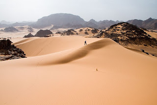
Geography

The Sahara covers large parts of Algeria, Chad, Egypt, Libya, Mali, Mauritania, Morocco, Niger, Western Sahara, Sudan and Tunisia. It is one of three distinct physiographic provinces of the African massive physiographic division.

The desert landforms of the Sahara are shaped by wind (Aeolian processes) or by occasional rains, and include sand dunes and dune fields or sand seas (erg), stone plateaus (hamada), gravel plains (reg), dry valleys (wadi), and salt flats (shatt or chott). Unusual landforms include the Richat Structure in Mauritania.

Several deeply dissected mountains and mountain ranges, many volcanic, rise from the desert, including the Aïr Mountains, Ahaggar Mountains, Saharan Atlas, Tibesti Mountains, Adrar des Iforas, and the Red Sea hills. The highest peak in the Sahara is Emi Koussi, a shield volcano in the Tibesti range of northern Chad.

Most of the rivers and streams in the Sahara are seasonal or intermittent, the chief exception being the Nile River, which crosses the desert from its origins in central Africa to empty into the Mediterranean. Underground aquifers sometimes reach the surface, forming oases, including the Bahariya, Ghardaïa, Timimoun, Kufrah, and Siwah.

The central part of the Sahara is hyper-arid, with little vegetation. The northern and southern reaches of the desert, along with the highlands, have areas of sparse grassland and desert shrub, with trees and taller shrubs in wadis where moisture collects.

To the north, the Sahara reaches to the Mediterranean Sea in Egypt and portions of Libya, but in Cyrenaica and the Magreb, the Sahara borders Mediterranean forest, woodland, and scrub ecoregions of northern Africa, which have a Mediterranean climate characterized by a winter rainy season. According to the botanical criteria of Frank White and geographer Robert Capot-Rey, the northern limit of the Sahara corresponds to the northern limit of Date Palm cultivation (Phoenix dactylifera), and the southern limit of Esparto (Stipa tenacissima), a grass typical of the Mediterranean climate portion of the Maghreb and Iberia. The northern limit also corresponds to the 100 mm (3.9 in) isohyet of annual precipitation.

To the south, the Sahara is bounded by the Sahel, a belt of dry tropical savanna with a summer rainy season that extends across Africa from east to west. The southern limit of the Sahara is indicated botanically by the southern limit of Cornulaca monacantha (a drought-tolerant member of the Chenopodiaceae), or northern limit of Cenchrus biflorus, a grass typical of the Sahel. According to climatic criteria, the southern limit of the Sahara corresponds to the 150 mm (5.9 in) isohyet of annual precipitation

Climate history

The climate of the Sahara has undergone enormous variation between wet and dry over the last few hundred thousand years. During the last glacial period, the Sahara was even bigger than it is today, extending south beyond its current boundaries. The end of the glacial period brought more rain to the Sahara, from about 8000 BC to 6000 BC, perhaps due to low pressure areas over the collapsing ice sheets to the north.

Once the ice sheets were gone, northern Sahara dried out. In the southern Sahara though, the drying trend was soon counteracted by the monsoon, which brought rain further north than it does today. The monsoon is due to heating of air over the land during summer. The hot air rises and pulls in cool, wet air from the ocean, which causes rain. Thus, though it seems counterintuitive, the Sahara was wetter when it received more insolation in the summer. This was caused by a stronger tilt in Earth's axis of orbit than today, and perihelion occurred at the end of July.

By around 3400 BC, the monsoon retreated south to approximately where it is today, leading to the gradual desertification of the Sahara. The Sahara is now as dry as it was about 13,000 years ago. These conditions are responsible for what has been called the Sahara pump theory.

The Sahara has one of the harshest climates in the world. The prevailing north-easterly wind often causes the sand to form sand storms and dust devils. Half of the Sahara receives less than 20 mm (0.79 in) of rain per year, and the rest receives up to 10 cm (3.9 in) per year. The rainfall happens very rarely, but when it does it is usually torrential when it occurs after long dry periods, which can last for years.

The southern boundary of the Sahara, as measured by rainfall, was observed to both advance and retreat between 1980 and 1990. As a result of drought in the Sahel, the southern boundary moved south 130 kilometres (81 mi) overall during that period. Deforestation has also caused the Sahara to advance south in recent years, as trees and bushes continue to be used as fuel source.

Recent signals indicate that the Sahara and surrounding regions are greening due to increased rainfall. Satellites show extensive regreening of the Sahel between 1982 and 2002, and in both Eastern and Western Sahara a more than 20 year long trend of increased grazing areas and flourishing trees and shrubs has been observed by climate scientist Stefan Kröpelin.

Snow and ice

On February 18, 1979, snowfall in several places in southern Algeria, including a half-hour snowstorm that stopped traffic in Ghardaïa, was reported in newspapers around the world as '[snow in the Sahara] for the first time in living memory'. The snow was gone within hours.

Several Saharan mountain ranges, however, receive snow on a more regular basis. Although relative humidity is low in the arid environment, the absolute humidity is sufficiently high to condense when driven up a mountain range. In winter, temperatures drop low enough on the 3,003 meters (9,852 ft) Tahat summit, highest peak of the Ahaggar Mountains, to cause snow every third year; the inaccessible Tibesti Mountains are said to receive snow on peaks over 2,500 meters (8,202 ft) every seventh year.

Ecoregions

The Sahara comprises several distinct ecoregions, whose variations in temperature, rainfall, elevation, and soils harbor distinct communities of plants and animals. According to the World Wide Fund for Nature (WWF), the ecoregions of the Sahara include:

*Atlantic coastal desert

*North Saharan steppe and woodlands

*Sahara desert

*South Saharan steppe and woodlands

*West Saharan montane xeric woodlands

*Tibesti-Jebel Uweinat montane xeric woodlands

*Saharan halophytics

*Tanezrouft

Flora and fauna

*Dromedary camels and goats

*The Leiurus quinquestriatus (aka deathstalker) scorpion

*The monitor lizard

*Sand vipers

*The African Wild Dog

*The fennec fox, pale fox and Rüppell's fox

*The hyrax

*The ostrich

*The addax, a large white antelope

*The Saharan cheetah

*The dorcas gazelle

There exist other animals in the Sahara (birds in particular) such as African Silverbill and Black-throated Firefinch among others.

The central Sahara is estimated to include only five hundred species of plants, which is extremely low considering the huge extent of the area. Plants such as acacia trees, palms, succulents, spiny shrubs, and grasses have adapted to the arid conditions, either by reducing water loss or storing water. Plant leaves may dry out totally and then recover. Human activities are more likely to affect the habitat in areas of permanent water (oases) or where water comes close to the surface. Here, the local pressure on natural resources can be intense. The remaining populations of large mammals have been greatly reduced by hunting for food and recreation. In recent years development projects have started in the deserts of Algeria and Tunisia using irrigated water pumped from underground aquifers. These schemes often lead to soil degradation and salinization.

credited to wikipedia

Read On 0 comments

Namib


The Namib Desert is a desert in Namibia and southwest Angola that forms part of the Namib-Naukluft National Park. The name "Namib" is of Nama origin and means vast.

The desert occupies an area of around 80,900 km² (31,200 square miles), stretching about 1,000 miles (1,600 km) along the Atlantic Ocean coast of Namibia. Its east-west width varies from 30 to 100 miles (50-160 km). The Namib Desert also reaches into southwest Angola. It is one of the 500 distinct physiographic provinces of the South African Platform physiographic division.

Having endured arid or semi-arid conditions for at least 55 million years, it is considered to be the oldest desert in the world. The Namib's aridity is caused by the descent of dry air of the Hadley Cell, cooled by the cold Benguela current along the coast. It has less than 10 mm (0.4 inches) of rain annually and is almost completely barren.

A number of unusual species of plants and animals are found only in this desert. One of these is Welwitschia mirabilis, one of the most unusual species. Welwitschia is a shrub-like plant, but grows just two long strap-shaped leaves continuously throughout its lifetime. These leaves may be several meters long, gnarled and twisted from the desert winds. The taproot of the plant develops into a flat, concave disc in age. Welwitschia is notable for its survival in the extremely arid conditions in the Namib, sometimes deriving moisture from the coastal sea fogs.

Although the desert is largely unpopulated and inaccessible, there are year-round settlements at Sesriem, close to the famous Sossusvlei and a huge group of sand dunes, which at more than 300 meters (984 ft) high are among the tallest sand dunes in the world. The complexity and regularity of dune patterns in its dune sea have attracted the attention of geologists for decades. They still remain poorly understood.

The interaction between the water-laden air coming from the sea via southerly winds, some of the strongest of any coastal desert, and the dry air of the desert causes immense fogs and strong currents, causing sailors to lose their way. Along with the Skeleton Coast further north, it is notorious as the site of many shipwrecks. Some of these wrecked ships can be found as much as 50 metres (55 yds) inland, as the desert slowly moves westwards into the sea, reclaiming land over a period of many years.

The Namib desert is an important location for the mining of tungsten, salt and diamonds. As documented in some extraordinary detail in the BBC Planet Earth (TV series) episode #5 on deserts, there is a struggle for existence in this desert by elephants, lions, oryx and other valiant survivors, a struggle that is surprising in that anything can find sustenance here at all. (A pair of oryx is seen on the Namibian coat of arms.)

Access is by light aircraft from Windhoek (the capital of Namibia, about 480 km (298 mi) north-east of the centre of the desert), Swakopmund and Walvis Bay at the north end of the desert, or overland on gravel roads.

credited to wikipedia

Read On 0 comments

Gobi


The Gobi is a large desert region in Asia. It covers parts of northern and northwestern China, and of southern Mongolia. The desert basins of the Gobi are bounded by the Altai Mountains and the grasslands and steppes of Mongolia on the north, by the Hexi Corridor and Tibetan Plateau to the southwest, and by the North China Plain to the southeast. The Gobi is made up of several distinct ecological and geographic regions based on variations in climate and topography. This desert is the fifth largest in the world.

The Gobi is most notable in history as part of the great Mongol Empire, and as the location of several important cities along the Silk Road.

The Gobi is a rain shadow desert formed by the Himalaya range blocking rain-carrying clouds from reaching the Gobi.

Geography

The Gobi measures over 1,610 km (1,000 mi) from southwest to northeast and 800 km (497 mi) from north to south. The desert is widest in the west, along the line joining the Lake Bosten and the Lop Nor (87°-89° east). It occupies an arc of land 1,295,000 km2 (500,002 sq mi) in area, making it fifth largest in the world and Asia's largest. Much of the Gobi is not sandy but is covered with bare rock.

A relatively large area on the east side of the Greater Khingan range, between the upper waters of the Songhua (Sungari) and the upper waters of the Liao-ho, is also reckoned to belong to the Gobi by conventional usage. On the other hand, geographers and ecologists prefer to regard the western area of the Gobi region (as defined above), the basin of the Tarim in Xinjiang and the desert basin of Lop Nor and Hami (Kumul) as forming a separate and independent desert, called the Taklamakan Desert.

The Nemegt Basin in the northwestern part of the Gobi Desert (in Mongolia) is famous for its fossil treasures, including early mammals, dinosaur eggs, and even prehistoric stone implements, some 100,000 years old.

Climate

The Gobi is a cold desert, and it is not uncommon to see frost and occasionally snow on its dunes. Besides being quite far north, it is also located on a plateau roughly 910–1,520 meters (3,000–5,000 ft) above sea level, which further contributes to its low temperatures. An average of approximately 194 millimeters (7.6 in) of rain falls per year in the Gobi. Additional moisture reaches parts of the Gobi in winter as snow is blown by the wind from the Siberian Steppes. These winds cause the Gobi to reach extremes of temperature ranging from –40°C (-40°F) in winter to +50°C (122°F) in summer.

The climate of the Gobi is one of great extremes, combined with rapid changes of temperature, not only through the year but even within 24 hours (by as much as 35 °C or 61 °F).

Even in southern Mongolia the thermometer goes down as low as -32.8 °C (-27 °F), and in Alxa it rises as high as 37 °C (98.6 °F) in July.

Average winter minimals are a frigid -40 °C (-40 °F) while summertime temperatures are warm to hot, highs range up to 50 °C (122 °F). Most of the precipitation falls during the summer.

Although the southeast monsoons reach the southeast parts of the Gobi, the area throughout this region is generally characterized by extreme dryness, especially during the winter. Hence, the icy sandstorms and snowstorms of spring and early summer plus early January (winter).

Conservation, ecology, economy

The Gobi Desert is the source of many important fossil finds, including the first dinosaur eggs.

These deserts and the surrounding regions sustain many animals, including black-tailed gazelles, marbled polecats, bactrian camels, Mongolian wild ass and sandplovers, and are occasionally visited by snow leopards, brown bears, and wolves. The desert features a number of drought-adapted shrubs such as gray sparrow's saltwort, gray sagebrush, and low grasses such as needle grass and bridlegrass.

The area is vulnerable to trampling by livestock and off-road vehicles (human impacts are greater in the eastern Gobi Desert, where rainfall is heavier and may sustain livestock). In Mongolia, grasslands have been degraded by goats, raised by nomadic herders as source of cashmere wool. Economic trends of livestock privatization and the collapse of the urban economy have caused people to return to rural lifestyles, a movement contrary to urbanization.

Large copper and gold deposits located at Oyuu Tolgoi, about 80 kilometers from the Chinese border into Mongolia, are being investigated for mining operations.

Desertification

Currently, the Gobi desert is expanding at an alarming rate, in a process known as desertification. The expansion is particularly rapid on the southern edge into China, which has seen 3,600 km2 (1,390 sq mi) of grassland overtaken every year by the Gobi Desert. Dust storms, which used to occur regularly in China, have seen a dramatic increase in occurrence in the past 20 years, mainly due to desertification, and causing further damage to China's agriculture economy.

The expansion of the Gobi is attributed mostly to human activities, notably deforestation, overgrazing, and depletion of water resources. China has made various plans to try to slow the expansion of the desert, which have met with some small degree of success, but usually have no major impact. The most recent plan involves the planting of the Green Wall of China, a huge ring of newly-planted forests that the Chinese government hopes will act as a buffer against further expansion.

credited to wikipedia

Read On 0 comments

Atacama


The Atacama Desert is a virtually rainless plateau in South America, covering a 600-mile (1,000 km) strip of land on the Pacific coast of South America, west of the Andes mountains. The Atacama desert is, according to NASA, National Geographic and many other publications, the driest desert in the world, due to the rain shadow on the leeward side of the Chilean Coast Range, as well as a coastal inversion layer created by the cold offshore Humboldt Current. The Atacama occupies 40,600 square miles (105,000 km2) in northern Chile, composed mostly of salt basins (salares), sand, and lava flows.

Setting

The Atacama Desert ecoregion, as defined by the Worldwide Fund for Nature (WWF), extends from a few kilometers south of the Chile-Peru border to about 30° south latitude. To the north lies the Sechura Desert ecoregion, in Peru, whilst to the south is the Chilean Matorral ecoregion. The National Geographic Society considers the coastal area of southern Peru to be part of the Atacama desert, including the deserts south of the Ica Region.

To the east lies the less arid Central Andean dry puna ecoregion. The drier portion of this ecoregion is located south of the Loa River between the parallel Sierra Vicuña Mackenna and Cordillera Domeyko. To the north of the mentioned river lies the Pampa del Tamarugal.

The driest desert

The Atacama is one of the driest places on Earth, and is virtually sterile because it is blocked from moisture on both sides by the Andes mountains and by the Chilean Coast Range. A coastal inversion layer created by the cold Humboldt Current and the anticyclone of the Pacific is essential to keep the climate of the Atacama dry. The average rainfall in the Chilean region of Antofagasta is just 1 millimetre (0.04 in) per year. Some weather stations in the Atacama have never received rain. Evidence suggests that the Atacama may not have had any significant rainfall from 1570 to 1971. It is so arid that mountains that reach as high as 6,885 metres (22,589 ft) are completely free of glaciers and, in the southern part from 25°S to 27°S, may have been glacier-free throughout the Quaternary, though permafrost extends down to an altitude of 4,400 metres (14,400 ft) and is continuous above 5,600 metres (18,400 ft). Studies by a group of British scientists have suggested that some river beds have been dry for 120,000 years.

Some locations in the Atacama do receive a marine fog known locally as the Camanchaca, providing sufficient moisture for hypolithic algae, lichens and even some cacti. But in the region that is in the "fog shadow" of the high coastal crest-line, which averages 3,000 metres (10,000 ft) m height for about 100 kilometres (60 mi) south of Antofagasta, the soil has been compared to that of Mars. Due to its otherworldly appearance, the Atacama has been used as a location for filming Mars scenes, most notably in the television series Space Odyssey: Voyage to the Planets. The desert was also prominently featured in the 2008 James Bond film Quantum Of Solace.

In 2003, a team of researchers published a report in Science magazine titled "Mars-like Soils in the Atacama Desert, Chile, and the Dry Limit of Microbial Life" in which they duplicated the tests used by the Viking 1 and Viking 2 Mars landers to detect life, and were unable to detect any signs in Atacama Desert soil. The region may be unique on Earth in this regard and is being used by NASA to test instruments for future Mars missions. The team duplicated the Viking tests in Mars-like Earth environments and found that they missed present signs of life in soil samples from Antarctic dry valleys, the Atacama Desert of Chile and Peru, and other locales.

In 2008, the Phoenix Mars Lander detected perchlorates on the surface of Mars at the same site where water was first discovered. Perchlorates are also found in the Atacama and associated nitrate deposits have contained organics, leading to speculation that signs of life on Mars are not incompatible with perchlorates. The Atacama is also a testing site for the NASA funded Earth-Mars Cave Detection Program.

credited to wikipedia

Read On 0 comments

Ténéré


The Ténéré is a desert region in the south central Sahara. It comprises a vast plain of sand stretching from northeastern Niger into western Chad, occupying an area of over 154,440 square miles (400,000 km²). Its boundaries are said to be the Aïr Mountains in the west, the Hoggar Mountains in the north, the Djado Plateau in the northeast, the Tibesti Mountains in the east, and the basin of Lake Chad in the south.

Name

The name Ténéré comes from the Tuareg language, meaning "desert", in much the same way that the Arabic word for "desert", Sahara, came to be applied to the region as a whole.

Climate

The Ténéré is arid, with an extremely hot and dry climate and virtually no plant life. Temperatures reach as high as 42 °C (108 °F) in the summer, with little more than 25 mm (1 in) of rain annually. Water is notoriously difficult to find, even underground, and wells may be hundreds of miles apart.

Topography

Most of the Ténéré is a flat basin, once the bed of the prehistoric Lake Chad. In the north, the Ténéré is a vast sand sheet - the true, featureless 'Ténéré' of legend reaching up to the low hills of the Tassili du Hoggar along the Algerian border. In the centre the Bilma Erg, forms rows of easily navigable low dunes whose corridors make regular byways for the azelai or salt caravans. To the west, the Aïr Mountains rise up. To the south east the Ténéré is bordered by the Kaour cliffs running 100 km north to south. At the base lie a string of oases including the famous Bilma The total eclipse of March 2006 passed through this region at which time people in Dirkou were seen running for the mosque. Periodic outcrops, such as the unusual marble Blue Mountains in the northwest near Adrar Chiriet, or the Agram hills near the oasis of Fachi and Adrar Madet to the north, are rare but notable landmarks.

History

The region was not always a desert. During the prehistoric Carboniferous period it was a sea floor and later a tropical forest. A major dinosaur cemetery lies southeast of Agadez at Gadoufaoua; many fossils have been found there, having eroded out from the ground. An almost complete specimen of the crocodile-like reptile Sarcosuchus imperator, nicknamed the SuperCroc, was discovered there by paleontologists.

During early human history, it was a fertile land much more congenial to human life than it is now. The region was inhabited by modern humans as long ago as the Paleolithic period some 60,000 years ago. They hunted wild animals and left evidence of their presence in the form of stone tools including tiny, finely carved arrow heads. During the Neolithic period about 10,000 years ago, ancient hunters, the Kiffian people, created rock engravings and paintings that can still be found across the region. The human population dwindled as the Sahara dried out, and by 2500 BC it had largely become as dry as it is today.

credited to wikipedia and flickr: 6franc6

Read On 0 comments

Kalahari


The Kalahari Desert (Dorsland in Afrikaans) is a large arid to semi-arid sandy area in Southern Africa extending 900,000 square kilometres (350,000 sq mi), covering much of Botswana and parts of Namibia and South Africa, as semi-desert, with huge tracts of excellent grazing after good rains. The Kalahari Desert is the southern part of Africa, and the geography is a portion of desert and a plateau. The Kalahari supports some animals and plants because most of it is not a true desert. There are small amounts of rainfall and the summer temperature is very high. It usually receives 3–7.5 inches (76–190 mm) of rain per year. The surrounding Kalahari Basin covers over 2,500,000 square kilometres (970,000 sq mi) extending farther into Botswana, Namibia and South Africa, and encroaching into parts of Angola, Zambia and Zimbabwe. The only permanent river, the Okavango, flows into a delta in the northwest, forming marshes that are rich in wildlife. Ancient dry riverbeds—called omuramba—traverse the Central Northern reaches of the Kalahari and provide standing pools of water during the rainy season. Previously havens for wild animals from elephant to giraffe, and for predators such as lion and cheetah, the riverbeds are now mostly grazing spots, though leopard or cheetah can still be found.

Climate

Derived from the Tswana word Kgala, meaning "the great thirst", or Khalagari, Kgalagadi or Kalagare, meaning "a waterless place", the Kalahari has vast areas covered by red sand without any permanent surface water. Drainage is by dry valleys, seasonally inundated pans, and the large salt pans of the Makgadikgadi Pan in Botswana and Etosha Pan in Namibia. However, the Kalahari is not a true desert. Parts of the Kalahari receive over 250 millimetres (9.8 in) of erratic rainfall annually and are quite well vegetated; it is only truly arid in the southwest with under 175 millimetres (6.9 in) of rain annually, making the Kalahari a fossil desert. Summer temperatures in the Kalahari range from 20 to 45°C (68–113°F).

The Kalahari Desert was once a much wetter place. The ancient Lake Makgadikgadi dominated the area, covering the Makgadikgadi Pan and other areas, until its final drainage some 10,000 years ago. It may have once covered as much as 275,000 square kilometres (106,000 sq mi) and was approximately 30 metres (98 ft) deep.

Ecology

Despite its aridity, the Kalahari supports a variety of fauna and flora. The native flora includes acacia trees and many other herbs and grasses. The Kiwano fruit, also known as the Horned Melon, melano, African horned cucumber, jelly melon, hedged gourd, and/or English tomato, is endemic to a region in the Kalahari Desert.

Some of the areas within the Kalahari are seasonal wetlands, such as the Makgadikgadi Pans of Botswana. This area, for example, supports numerous halophilic species, and in the rainy season, tens of thousands of flamingos visit these pans.

Game reserves

The Kalahari has a number of game reserves—the Central Kalahari Game Reserve (CKGR, the world's second largest protected area), Khutse Game Reserve and the Kgalagadi Transfrontier Park. Animals that live in the region include brown hyenas, lions, meerkats, giraffes, warthogs, jackals, several species of antelope (including the eland, gemsbok, springbok, hartebeest, steenbok, kudu, and duiker), and many species of birds and reptiles. Vegetation in the Kalahari consists mainly of grasses and acacias, but there are over 400 identified plant species present (including the wild watermelon, or Tsamma melon). Camel rides flourish when it rains.

Population

The Bushmen have lived in the Kalahari for 20,000 years as hunter-gatherers. They hunt wild game with bows and arrows and gather edible plants, such as berries, melons and nuts, as well as insects. Bushmen rarely drink water; they get most of their water requirements from plant roots and desert melons found on or under the desert floor. They often store water in the blown-out shells of ostrich eggs. The San languages are notable for a number of distinctive features, including click consonants. These Bushmen live in huts built from local materials—the frame is made of branches, and the roof is thatched with long grass. The Bantu-speaking Tswana, Kgalagadi, and Herero and a small number of European settlers also live in the Kalahari.

credited to wikipedia and flickr: Martin_Heigan

Read On 0 comments

Taklamakan


The Taklamakan Desert, also known as Taklimakan, is a desert in Central Asia, in the Xinjiang Uyghur Autonomous Region of the People's Republic of China. It is bounded by Kunlun Mountains to the south, and Pamir Mountains and Tian Shan (ancient Mount Imeon) to the west and north.

Taklamakan is known as one of the largest sandy deserts in the world, ranking 15th in size in a ranking of the world's largest non-polar deserts. It covers an area of 270,000 km² of the Tarim Basin, 1,000 km long and 400 km wide. It is crossed at its northern and at its southern edge by two branches of the Silk Road as travellers sought to avoid the arid wasteland. In recent years, the People's Republic of China has constructed a cross-desert highway that links the cities of Hotan (on the southern edge) and Luntai (on the northern edge).

Climate

Taklamakan is the paradigm of a cold desert. Given its relative proximity with the cold to frigid air masses in Siberia, extreme lows are recorded in wintertime, sometimes well below −20 °C (−4 °F) . During the 2008 Chinese winter storms episode the Taklamakan was reported to be for the first time covered in its entirety of a thin layer of snow reaching 4 centimetres (1.6 in) in some observatories.

Its extreme inland position, virtually in the very heartland of Asia and thousands of kilometres from any open body of water, accounts for the cold character of its nights even during summertime.

Oasis

There is no water on the desert and it is hazardous to cross. Takla Makan means "go in and you'll never come out" Merchant caravans on the Silk Road would stop for relief at the thriving oasis towns.

The key oasis towns, watered by rainfall from the mountains, were Kashgar, Marin, Niya, Yarkand, and Khotan (Hetian) to the south, Kuqa and Turfan in the north, and Loulan and Dunhuang in the east. Now many, such as Marin and Gaochang are ruined cities in sparsely inhabited areas in the Xinjiang Autonomous Region of the People's Republic of China.

The archeological treasures found in its sand buried ruins point to Tocharian, early Hellenistic, Indian and Buddhistic influences. Its treasures and dangers have been vividly described by Aurel Stein, Sven Hedin, Albert von Le Coq and Paul Pelliot. Mummies, some 4000 years old, have been found in the region. They show the wide range of peoples who have passed through. Some of the mummies appear European. Later, the Taklamakan was inhabited by Turkic peoples. Starting with the Tang Dynasty, the Chinese periodically extended their control to the oasis cities of the Taklamakan in order to control the important silk route trade across Central Asia. Periods of Chinese rule were interspersed with rule by Turkic and Mongol and Tibetan peoples. The present population consists largely of Turkic, Uyghur people.

credited to wikipedia

Read On 0 comments

Simpson


The Simpson Desert occupies approximately 176 500 square kilometres of central Australia. It is located within, and near the common boundaries of the Northern Territory, South Australia and Queensland states of Australia. It is bounded to the west by the Finke River and Mabel Range, to the north by the Adam Range, to the east by the Georgina and Diamantina Rivers, with Lake Eyre to the south. Average annual rainfall is less than 200 mm.

The Simpson Desert is underlain by the Great Artesian Basin, water from which rises to the surface at numerous natural springs, including Dalhousie Springs, and at bores drilled along stock routes, or during petroleum exploration. As a result of exploitation by such bores, the flow of water to springs has been steadily decreasing in recent years.

The Simpson Desert is an erg which contains the world's longest parallel sand dunes. These north-south oriented dunes are static, held in position by vegetation. They vary in height from 3 metres in the west to around 30 metres on the eastern side. The most famous dune, Nappanerica, or, more popularly, Big Red (named by Simpson Desert traveller Dennis Bartell), is 40 metres in height.

The explorer Charles Sturt, who visited the region from 1844-1846, was the first European to see the desert, but it was not until 1936 that Ted Colson became the first white person to cross it in its entirety. The name Simpson Desert was coined by Cecil Madigan, after Alfred Allen Simpson, an Australian philanthropist, geographer, and president of the Royal Geographical Society of South Australia.

No maintained roads cross the desert. However, there are tracks that were made during seismic surveys in the search for gas and oil during the 1960s and 1970s. These include the French Line, the Rig Road, and the QAA Line. Such tracks are still navigable by well-equipped four-wheel-drive vehicles which must carry extra fuel and water. Towns providing access to the edge of the Simpson Desert include Oodnadatta to the southwest, and Birdsville in the east. Last fuel on the western side is at the Mount Dare hotel and store. Before 1980, a section of the Commonwealth Railways Central Australian line passed along the western side of the Simpson Desert. Within the Simpson, the ruins at Dalhousie Springs, Dalhousie Springs, Purnie Bore wetlands, Approdinna Attora Knoll and Poeppel Corner (where Queensland, South Australia and Northern Territory meet) are popular landmarks.

Because of the excessive heat and inadequately experienced drivers attempting to access the desert in the past, it was decided to close the Simpson Desert during the summer of 2008-2009 — to save unprepared "adventurers" from themselves.

In 2010, researchers uncovered the courses of ancient river systems under the Simpson Desert.

credited to wikipedia and flickr: Toby Woolley

Read On 0 comments

Labels

Canyon (22) Caves (14) Desert (9) Gorges (11) Hills (9) Island (10) Lakes (18) Mountains (21) National Park (19) Others (20) Rivers (9) Rock formation (9) Volcano (13) Waterfalls (9)

All the pictures and news shown on this blog are the property of their respective owners. We don't hold any copyright about these pictures and news. These pictures have been collected from different public sourses including different websites, considering to be in public domain. If any one has any objection to displaying of any picture and news, it may be brought to our notice by sending email & the same will be be removed immediately,after verificaton of the claim. You can send us mail at:vladaerak@gmail.com