Ouzoud Falls

Ouzoud Waterfalls (French: Cascades d'Ouzoud) (110 m high) are located in the Grand Atlas
It is the most visited site of the region. In the vicinity, Green valleys, mills, orchards and a superb circuit of the gorges of the El Abid River (in Arabic, "Slaves' River" ), are found.
Ouzoud is the Berber word for "olive", referring to the nearby olive trees.
 The bottom of the falls is accessible through a shaded path of olive trees. At the summit of the falls, there exist a dozen of old small mills that are still in use. In the twilight, one can observe whole troops of monkeys. One can also follow a narrow and difficult track leading to the road of Beni Mellal while descending the gorges from the "wadi el-Abid" by a canyon sometimes which one does not distinguish the bottom with nearly 600 meters.
 Many local and national associations lead projects to protect and preserve the site.
Gouina Falls

The Gouina Falls or Chutes de Gouina are on the Sénégal River in Mali between the towns of Bafoulabé (upstream) and Diamou (downstream) in the Kayes Region, where the river runs north from the Talari Gorges.
 They have been called the "
 The government of
Blue Nile Falls

The
The falls are estimated to be between 37 and 45 meters high, consisting of four streams that originally varied from a trickle in the dry season to over 400 meters wide in the rainy season. Regulation of
 The
The
 A short distance downstream from the falls sits the first stone bridge constructed in
Augrabies Falls

The
The falls have recorded 7,800 cubic metres (280,000 cu ft) of water every second in floods in 1988 (and 6,800 cubic metres (240,000 cu ft) in the floods of 2006). This is over three times the average high season flow rate of Niagara Falls of 2,400 cubic metres (85,000 cu ft) per second, more than four times Niagara's annual average, and greater than Niagara's all time record of 6,800 cubic metres (240,000 cu ft) per second.
 The gorge at the
Niagara Falls

The
Niagara Falls were formed when glaciers receded at the end of the Wisconsin glaciation (the last ice age), and water from the newly formed Great Lakes carved a path through the Niagara Escarpment en route to the Atlantic Ocean. While not exceptionally high, the
The

The volume of water approaching the falls during peak flow season may sometimes be as much as 202,000 cubic feet (5,700 m3) per second. Since the flow is a direct function of the Lake Erie water elevation, it typically peaks in late spring or early summer. During the summer months, 100,000 cubic feet (2,800 m3) per second of water actually traverses the Falls, some 90% of which goes over the

When the ice melted, the upper Great Lakes emptied into the
Immediately below the hard-rock formation, comprising about two thirds of the cliff, lay the weaker, softer, sloping Rochester Formation (Lower Silurian). This formation was composed mainly of shale, though it has some thin limestone layers. It also contains ancient fossils. In time, the river eroded the soft layer that supported the hard layers, undercutting the hard caprock, which gave way in great chunks. This process repeated countless times, eventually carving out the Falls.
Submerged in the river in the lower valley, hidden from view, is the Queenston Formation (Upper Ordovician), which is composed of shales and fine sandstones. All three formations were laid down in an ancient sea, their differences of character deriving from changing conditions within that sea.
The

A number of figures have been suggested as first circulating an eyewitness description of
Jean de Brébeuf also may have visited the Falls, while spending time with the Neutral Nation.
 During the 18th century, tourism became popular, and by mid-century, it was the area's main industry. Napoleon Bonaparte's brother Jérôme visited with his bride in the early 19th century. In 1837 during the Caroline affair a rebel supply ship, the Caroline, was burned and sent over the Falls. Demand for passage over the Niagara River led in 1848 to the building of a footbridge and then Charles Ellet's
After the First World War, tourism boomed again as automobiles made getting to the Falls much easier. The story of
Iguazu Falls


On the Brazilian side there is a long walkway along the canyon with an extension to the lower base of the Devil's Throat. From Foz do Iguaçu airport the park can be reached by taxi (R$ 15-17) or bus (no 120) to entrance of the park. There is an entrance fee to the park. Free frequent buses are provided to various points within the park.The park opens at 9 am and closes at 5.30 pm. The town of
The Argentine access is facilitated by the Rainforest Ecological Train, which brings visitors to different walkways. The Paseo Garganta del Diablo is a one-kilometer-long trail that brings the visitor directly over the falls of the Devil's Throat. Other walkways allow access to the elongated stretch of falls on the Argentine side and to the ferry that connects to San Martin island.

The water falling over Iguazu in peak flow has a surface area of about 40 Ha (1.3 million ft²) whilst
However, Iguazu affords better views and walkways and its shape allows for spectacular vistas. At one point a person can stand and be surrounded by 260 degrees of waterfalls. The Devil's Throat, in
Victoria Falls

The Victoria Falls or Mosi-oa-Tunya (the Smoke that Thunders) is a waterfall located in southern Africa on the

The falls are formed as the full width of the river plummets in a single vertical drop into a transverse chasm 1708 meters (5604 ft) wide, carved by its waters along a fracture zone in the basalt plateau. The depth of the chasm, called the First Gorge, varies from 80 metres (262 ft) at its western end to 108 metres (360 ft) in the centre. The only outlet to the First Gorge is a 110-metre-wide (360 ft) gap about two-thirds of the way across the width of the falls from the western end, through which the whole volume of the river pours into the Victoria Falls gorges.
There are two islands on the crest of the falls that are large enough to divide the curtain of water even at full flood:
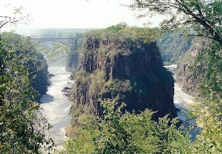
The
As the dry season takes effect, the islets on the crest become wider and more numerous, and in September to January up to half of the rocky face of the falls may become dry and the bottom of the First Gorge can be seen along most of its length. At this time it becomes possible (though not necessarily safe) to walk across some stretches of the river at the crest. It is also possible to walk to the bottom of the First Gorge at the Zimbabwean side. The minimum flow, which occurs in November, is around a tenth of the April figure; this variation in flow is greater than that of other major falls, and causes
Victoria Falls is roughly thrice the height of North America's

First Gorge: the one the river falls into at
Second Gorge: (spanned by the Victoria Falls Bridge), 250 m south of falls, 2.15 km long (270 yd south, 2350 yd long)
Third Gorge: 600 m south, 1.95 km long (650 yd south, 2100 yd long)
Fourth Gorge: 1.15 km south, 2.25 km long (1256 yd south, 2460 yd long)
Fifth Gorge: 2.55 km south, 3.2 km long (1.5 mi south, 2 mi long)
Songwe Gorge: 5.3 km south, 3.3 km long, (3.3 mi south, 2 mi long) named after the small
Batoka Gorge: The gorge below the Songwe is called the Batoka Gorge (which is also used as an umbrella name for all the gorges). It is about 120 kilometres (75 mi) long (the straight line distance to its end is about 80 kilometres (50 mi) east of the falls) and takes the river through the basalt plateau to the valley in which

Over at least 100,000 years, the falls have been receding upstream through the Batoka Gorges, eroding the sandstone-filled cracks to form the gorges. The river's course in the current vicinity of the falls is north to south, so it opens up the large east-west cracks across its full width, then it cuts back through a short north-south crack to the next east-west one. The river has fallen in different eras into different chasms which now form a series of sharply zig-zagging gorges downstream from the falls.
Ignoring some dry sections, the Second to Fifth and the Songwe Gorges each represents a past site of the falls at a time when they fell into one long straight chasm as they do now. Their sizes indicate that we are not living in the age of the widest ever falls.
The falls have already started cutting back the next major gorge, at the dip in one side of the "Devil's Cataract" (also known as "Leaping Waters") section of the falls. This is not actually a north-south crack, but a large east-northeast line of weakness across the river, where the next full-width falls will eventually form.
Further geological history of the course of the
The two national parks at the falls are relatively small —
On the Zambian side, fences and the outskirts of Livingstone tend to confine most animals to the
Mopane woodland savannah predominates in the area, with smaller areas of Miombo and Rhodesian Teak woodland and scrubland savannah. Riverine forest with palm trees lines the banks and islands above the falls. The most notable aspect of the area's vegetation though is the rainforest nurtured by the spray from the falls, containing plants rare for the area such as pod mahogany, ebony, ivory palm, wild date palm and a number of creepers and lianas. Vegetation has suffered in recent droughts, and so have the animals that depend on it, particularly antelope.
The national parks contain abundant wildlife including sizable populations of elephant, buffalo, giraffe, zebra, and a variety of antelope. Lion and leopard are only occasionally seen. Vervet monkeys and baboons are common. The river above the falls contains large populations of hippopotamus and crocodile. Elephants cross the river in the dry season at particular crossing points.
Klipspringers and clawless otters can be glimpsed in the gorges, but they are mainly known for 35 species of raptors. The Taita Falcon, Black Eagle, Peregrine Falcon and Augur Buzzard breed there. Above the falls, herons, Fish Eagles and numerous kinds of waterfowl are common.
The river is home to 39 species of fish below the falls and 89 species above it, mostly black cod and slippery trout. This illustrates the effectiveness of the falls as a dividing barrier between the upper and lower
Wallaman Falls

The
Angel Falls

Tourists sometimes refer to the stretch of the
There is an incredible variety of tropical wildlife in the area, including monkeys, poison arrow frogs, and hundreds of species of orchids. Aside from the monkeys, mammals in the area are generally difficult to spot but include giant anteaters, armadillos, porcupines, three-toed sloths, otters, jaguars, pumas, tapirs, and capybaras.
 Lying within the
This continent began to separate due to the formation of a fracture in the planet's crust resulting in the formation of the
The transformation of the landscape was due to drastic variations of arid climate to humid and vice versa; of strong, constant and lingering precipitations; droughts, freezing, discharges with high and low temperatures; storms, hurricanes, and the tectonic movements of the earth. The erosion was caused by atmospheric agents removing the material deposited in the great plain during millions of years. In places where the rock was less resistant, the erosion was greater resulting in this great transformation, the Tepuis, and the fantastic scenery at the Falls.
credited to newworldencyclopedia and flickr: Adrian Shepherd,Globe Trodden
