
The Verdon Gorge (in French: Gorges du Verdon or Grand canyon du Verdon), in south-eastern France (Alpes-de-Haute-Provence), is a river canyon that is considered by many to be Europe's most beautiful. It is the world's second largest gorge, at about 25 kilometers in length and up to 700 meters deep. It was formed by the Verdon River, which is named after its startling turquoise-green colour, one of the canyon's most distinguishing characteristics. The most impressive part lies between the towns of Castellane and Moustiers-Sainte-Marie, where the river has cut a ravine up to 700 metres down through the limestone mass. At the end of the canyon, the Verdon river flows into the artificial lake of Sainte-Croix-du-Verdon (in French: Lac de Sainte-Croix).
Because of its proximity to the French Riviera, the canyon is very popular with tourists, who can drive around its rim, rent kayaks or hike. The limestone walls, which are several hundreds of meters high, attract many rock climbers. It is considered an outstanding destination for multi-pitch climbing. There are routes encompassing cracks, pillars and seemingly endless walls. The climbing is generally of a technical nature, and there are over 1,500 routes, ranging from 20m to over 400m.
History
During the Triassic period, the French region of Provence subsided and was covered by the sea, leaving thick layers of various limestone deposits. Several million years later, with the arrival of the Jurassic period, the area was covered by a warm shallow sea, which allowed the growth of various Corals. The Cretaceous period saw what is now Basse Provence being raised and the sea reaching the current location of the Alps, which were themselves erected during the tertiary era. As a result of the large scale geological activity resulting from this, many of the Jurassic limestone deposits fractured, forming relief with valleys and other such features. Indeed, it is to this epoch that the origins of the Verdon Gorge can be traced. The dawn of the Quaternary period witnessed large scale glaciation, transforming water pockets and lakes into unstoppable rivers of ice, which remodeled the topography, scouring and striating the landscape. At the end of this activity, erosion by rivers continued, forming the Gorge as it is today. The Verdon’s river bed was scoured for a second time of the accumulated coral and limestone sediments, by a water delivery rate nearing 2000 to 3000 cubic metres per second.
Recent developments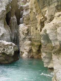
On the 10th July 2006, the French Conseil d'État annulled the declaration of public use of the EDF (Électricité de France; Electricity of France)’s project, relating to a high voltage line carrying 400,000 volts which would have had to pass through the Verdon Gorge. This decision ended 23 years of struggle by public groups and associations of environmental defense to preserve a site of exceptional natural interest, of which a part contains protected animal and plant species.
Geography
The source of the Verdon is close to the col d'Allos hill in the Trois Eveches mountain range, from where it continues, flowing into the Durance river near Vinon-sur-Verdon after traveling 175 kilometres. The most interesting part of this journey is found between Castellane and the Pont du Galetas, on the lac de Sainte-Croix. Some decades ago, this Lake used to be the large plain of Les Salles-sur-Verdon, before the construction of a reservoir created by the erecting of the Sainte-Croix dam. At the time of the raising of the water level in 1973, the old village des Salles was evacuated by force, destroyed and inundated. The church was dynamited, as was the rest of the village, which has been reconstructed higher up the valley as a more modern settlement, to the great displeasure of its inhabitants. Today, it is the youngest village in France.
For some distance the Verdon Gorge forms the border between the départements of Var to the south and Alpes-de-Haute-Provence to the north in the Provence-Alpes-Côte d'Azur région.
This region, between Castellan and the Lac de Sainte-Croix is called the ‘’’Gorges du Verdon’’’; ‘’’Verdon Gorge’’’. It is split into three distinct parts:
* The “Prégorges” (‘pre-gorge’) which goes from Castellane to Pont de Soleils
* The Gorge itself which goes from Pont de Soleils to l'Imbut, and
* The Canyon which goes from l’Imbut to the Pont de Galetas.
The Verdon Gorge is narrow and deep, with depths of 250 to 700 metres and widths of 6 to 100 metres at the level of the Verdon river, and 200 to 1500 metres from one side of the Gorge to the other at the summit.
credited to wikipedia


Post a Comment